Is your ideal Cape Cod home a dune-framed beach cottage, a quiet pond retreat, or a harbor hideaway with your boat steps away? Choosing the right waterfront on Cape Cod starts with knowing how each shoreline type lives, performs, and is regulated. You want beauty and access, but you also want to understand risk, permits, and long-term costs. This guide breaks down Harwich’s most common waterfront property types so you can move forward with confidence. Let’s dive in.
Waterfront types in Harwich
Oceanfront and Soundfront on Nantucket Sound
If you picture soft sand and open horizons, you are likely thinking of homes facing Nantucket Sound. These parcels can offer direct beach access, sweeping views, and strong buyer demand. They also see higher wave energy, seasonal overwash, and dune movement during coastal storms.
Expect careful review when you plan projects near the shoreline. Work near or below mean high water can trigger Chapter 91 tidelands licensing and local Conservation Commission review. For coastal policies and public trust principles, consult the Massachusetts Office of Coastal Zone Management.
Bay and cove frontage
Sheltered bays and coves offer calmer waters, broad tidal flats, and great sunset potential. These settings can be friendly for small craft, but depth varies with the tide and sensitive habitats like eelgrass and shellfish beds are common. Moorings, floats, or docks may require extra review to avoid resource impacts.
Permits can be more complex in these environments. The Cape Cod Commission provides regional context on coastal planning and water quality, which is helpful when evaluating estuaries and embayments. CZM resources also outline how eelgrass and shellfish protections affect use and permitting.
Harborfront, marina, and dockside
Living by a harbor or marina gives you direct boating access and a lively nautical setting. You may have a slip, a mooring, or proximity to managed harbor facilities. Conditions are more protected, though dredging cycles and harbor management can change access over time.
Expect a multi-agency process for any private dock or float. Start at the Town of Harwich for local harbormaster rules, then layer in Conservation Commission review and any state approvals for structures in tidelands.
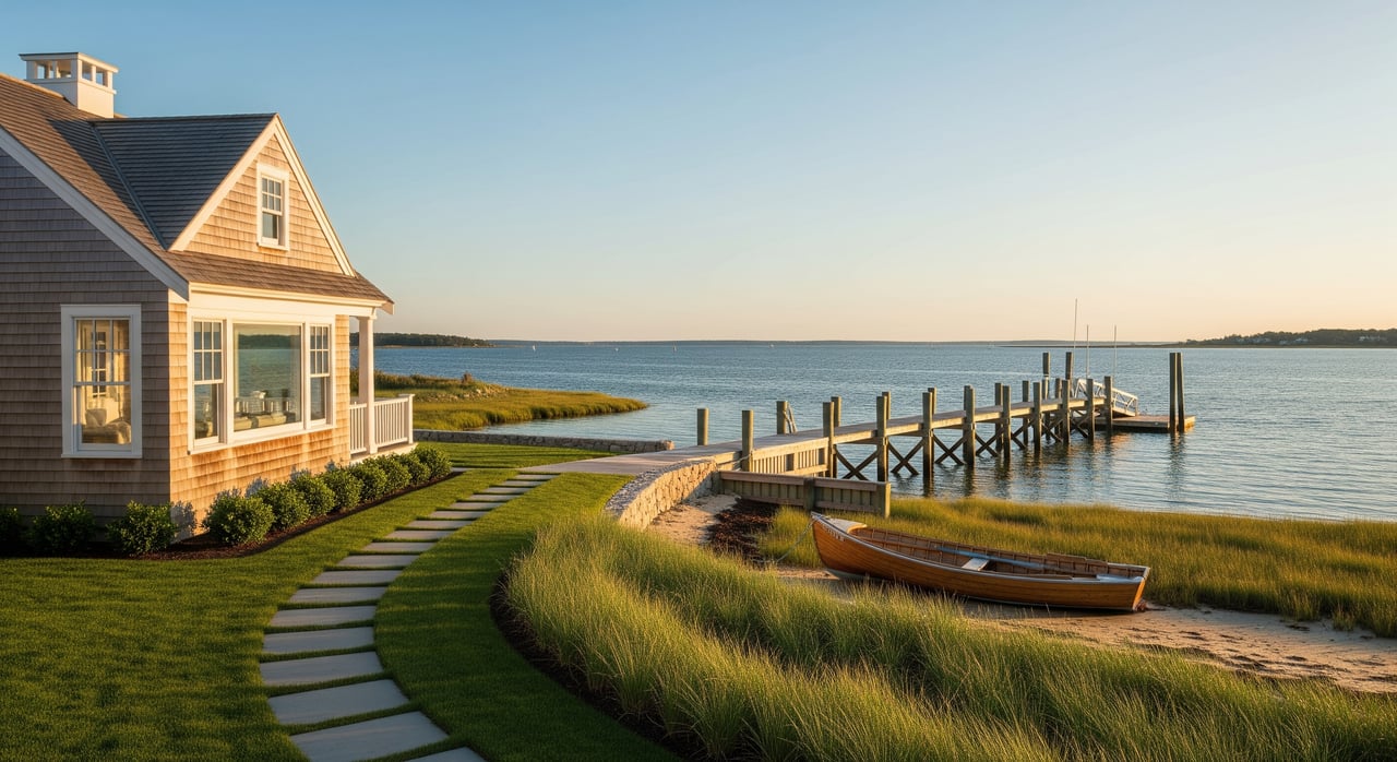
Riverfront and tidal creek
River and tidal creek homes feel close to nature, with wildlife, fishing, and small-boat opportunities. Banks and marsh edges can erode, and access depth changes with the tide. Septic performance matters, since these waterways are sensitive to nutrient loading.
Projects along tidal banks typically require review under the Wetlands Protection Act. You can learn about resource protections and coastal permitting frameworks through Massachusetts CZM, then coordinate locally on specifics.
Freshwater pondfront
Pondfront properties on Cape Cod’s kettle ponds offer clear water, swimming, and a quieter setting. These homes avoid salt spray and storm surge, and often support paddling or low-power boating. Water quality is a key focus, since septic and lawn care can influence algae growth.
Permits still apply near pond shorelines, and some ponds have added protections. Local Conservation Commissions implement the Massachusetts Wetlands Protection Act process, with state-level guidance available on Mass.gov.
Salt marsh or estuarine edge
Marsh-view homes deliver serene, ever-changing scenery and high ecological value. Many of these sites are low lying with limited dry buildable area. Flooding and tidal inundation risks are higher, and expansion can be very constrained.
Regulations are strict to protect wetlands and water quality. Before planning any work, get familiar with the Wetlands Protection Act process through state resources on Mass.gov and consult your local Conservation Commission early.
Bluff or coastal cliff frontage
Bluff-top homes offer elevated vistas and more separation from day-to-day wave action. Elevation can reduce some flood exposure, but erosion and bluff retreat are real concerns. Setbacks, historic erosion rates, and engineering feasibility all matter.
Study the erosion history before you buy or build. The USGS Coastal Change Hazards Portal provides shoreline change data and tools that help you evaluate long-term stability.
Barrier beach or spit
Barrier beaches sit at the frontline between open water and back-bay marshes. They are beautiful and dynamic, with high exposure to storm overwash and breaching. Insurance, repairs, and rebuilding may be costly or constrained.
These areas often carry the most stringent oversight. For context on coastal dynamics and resilience, explore the NOAA Sea Level Rise Viewer and CZM planning resources before committing to major projects.
Local factors that shape value and risk
Flooding and sea-level rise
Sea-level rise and more frequent coastal flooding are important considerations across Cape Cod. Use the NOAA Sea Level Rise Viewer to explore parcel-level scenarios. Then confirm current flood zones and base flood elevations with FEMA’s Flood Map Service Center.
Erosion and shoreline change
Cape shorelines move. Erosion rates vary by location, storm history, and shoreline type. Before you invest, review historic aerials and the USGS Coastal Change Hazards Portal to understand past retreat and future risk.
Water quality and septic
Nitrogen loading affects estuaries, eelgrass, and shellfish resources around Barnstable County. The Cape Cod Commission shares wastewater and coastal planning updates that may influence future permitting or septic upgrades. Expect Title 5 compliance checks and, in some watersheds, enhanced denitrifying systems for new work.
Public trust and access
In Massachusetts, public trust rights generally cover navigation and fishing in tidal waters. Ownership often ends near mean high water, and rules vary by parcel. For a plain-language overview, see guidance from the Massachusetts Office of Coastal Zone Management and verify specifics with a current survey and title review.
Permitting and insurance basics
Shoreline structures and docks
Docks, floats, and other water-dependent structures require local Conservation Commission approval. If work extends over tidelands, you will likely need state review as well. Learn about the tidelands licensing framework through MassDEP Chapter 91 information on Mass.gov, then coordinate with the Town on local requirements.
Flood insurance and lending
If a structure sits in a Special Flood Hazard Area, a lender will typically require flood insurance. Premiums depend on flood zone, elevation, and building features, and an elevation certificate can help refine pricing. Start with FEMA’s guide to flood insurance and verify your map status at the Flood Map Service Center.
Buyer and seller due diligence checklist
- Order a recent instrument survey that shows boundaries to the shoreline and any structures, including the tidal datum used.
- Inspect foundations, pilings, and materials for corrosion or water intrusion. For docks or bulkheads, schedule a marine-structure inspection.
- Review historic shoreline change and storm impacts using the USGS Coastal Change Hazards Portal.
- Confirm building elevations and consider an elevation certificate for insurance and lending.
- Verify Title 5 septic compliance and any watershed-specific upgrade requirements noted by the Cape Cod Commission.
- Check FEMA flood zones through the Flood Map Service Center and speak with the Town’s floodplain administrator.
- Ask the Town of Harwich Conservation Commission about past permits, Orders of Conditions, and any enforcement actions on the property.
- If you plan a dock or float, expect consultation about eelgrass and shellfish resources with the Massachusetts Division of Marine Fisheries.
Which waterfront fits your lifestyle?
- Choose oceanfront or Soundfront if daily beach access and wide-open views top your list. Be ready for higher insurance, dune care, and more permitting steps for improvements.
- Pick a bay or cove if you want calmer waters for kayaking or a skiff, and you are comfortable with tidal flats and habitat-focused permitting.
- Go harborfront if boating convenience is essential and you value managed infrastructure, mooring access, and a nautical setting.
- Select riverfront or tidal creek if you want wildlife and protected paddling, and you are mindful of bank stability and septic performance.
- Opt for pondfront if you prefer quieter waters, freshwater swimming, and less exposure to salt and storm surge.
- Consider marsh edge or barrier beach only if you accept higher flood risk and stricter building limits in exchange for exceptional scenery and access.
Get local guidance for a smart move
The best waterfront choice balances your lifestyle with site realities like flood zones, erosion trends, and permitting pathways. With the right plan, you can enjoy the Cape Cod experience while protecting your investment. If you want help aligning properties with your goals and risk comfort, connect for a private, data-informed consultation with Shane Masaschi.
FAQs
What types of waterfront exist in Harwich and how do they differ?
- Oceanfront and Soundfront offer direct beach access and high wave energy; bays and coves are more sheltered; harborfront adds managed boating access; riverfront and tidal creeks are protected but tidal; pondfront is freshwater and quieter; marsh edge and barrier beaches have higher flood and permitting constraints.
How do I check flood risk for a Harwich waterfront home?
- Start with FEMA’s Flood Map Service Center for current zones, then review future scenarios with the NOAA Sea Level Rise Viewer and consult the Town’s floodplain administrator.
Can I build a dock on a Harwich waterfront property?
- Most docks and floats need Conservation Commission approval, possible Chapter 91 review, and habitat consultations; begin with the Town of Harwich and plan for eelgrass and shellfish considerations via the Division of Marine Fisheries.
Do I own the beach in front of my Cape Cod home?
- Ownership depends on the deed and the mean high water boundary; in Massachusetts, public trust rights apply to tidal areas, so confirm specifics with a survey and see guidance from Massachusetts CZM.
Will I need flood insurance and how are premiums set?
- Lenders typically require it in Special Flood Hazard Areas; costs depend on zone, elevation, and building features, and you can learn the basics from FEMA’s flood insurance resources and an elevation certificate assessment.